Banded Snowfall in Colorado
When one thinks of Colorado, snow is often one of the first topics that come to mind. Due to the intricate topography and mesoscale features that characterize this state, snowstorms here frequently lead to uneven snow accumulation across different regions. For instance, while Lakewood might receive 12.0 inches of snow during a storm, Denver International Airport (DIA) might only get 5.0 inches. One of the factors that can contribute to this difference is known as “banded snow.”
Banding of heavier precipitation is a common occurrence, manifesting in almost every mid-latitude storm system, and it can be caused by several atmospheric dynamics. To grasp the complexity of predicting the intensity and location of snow bands, one must delve into the underlying atmospheric dynamics and current conditions. Below, we explore various scenarios at a high level, that can induce banded snowfall.
Northwestern Flow Aloft:
In this scenario, the upper-level jet stream is oriented in a northwest to southeast direction over the state. Northwest flow typically results in dry conditions or light snowfall, with the majority of the snow concentrated in the northwest mountains. Here, the jet stream dips over the state, with the continental divide separating cold Canadian air to the east from relatively warmer Pacific air to the west [Fig.1]. This setup is marked by a cold front pressing against the Front Range foothills, often accompanied by an east/northeast wind, supplying low-level moisture [Fig.2]. This moisture can lead to low-level clouds, fog, freezing mist/drizzle, or light snow.
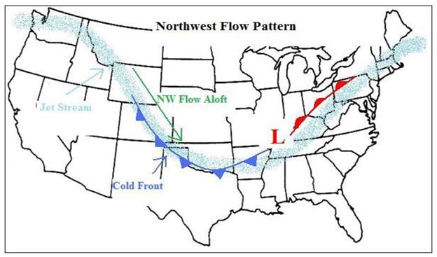
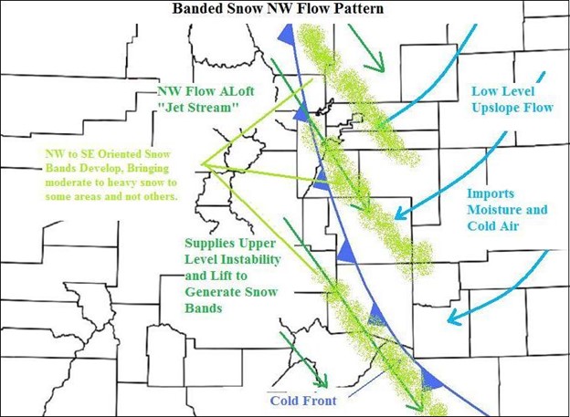
The “upslope flow” in this scenario is shallow due to northwest winds aloft drying the air as it descends from the high mountains, resulting in a dry layer of air above the saturated layer near the surface. This limits vertical cloud development and often leads to light snowfall or wintry mix conditions instead of heavy snow. However, the presence of the jet stream aloft can support snowfall east of the continental divide by forcing air upwards at the surface. These areas, where upper-level dynamics generate more intense precipitation, often experience banded snowfall due to the winds aloft.
In the case of northwest flow, while the orientation (NW->SE) can be predicted by upper-level winds, forecasting the intensity and location of snow bands remains challenging. Once a band of heavier precipitation forms, it may exhibit minimal geographic movement due to stable upper-level conditions, although individual storm cells within the band can move rapidly.
Southwestern Flow Aloft:
Contrary to northwest flow, the southwest flow pattern shares similarities at the surface but exhibits significant differences in the upper levels. In this scenario, cold air is typically ushered in by a cold front, leaving colder air in the eastern portions of the state. The jet stream, oriented from southwest to northeast, results in southwest to northeast-oriented snow bands.
Ahead of an approaching trough of low pressure, southwest flow acts akin to a warm front, bringing moisture from the desert southwest that overrides the colder air at the surface on the eastern plains. This setup can lead to light snow, but it also has the potential for freezing rain/mist/drizzle events. Heavier bands develop as jet stream energy passes overhead, providing additional energy and lift, which translates into heavier precipitation bands reaching the plains.
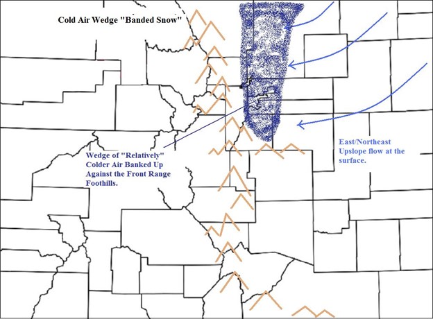
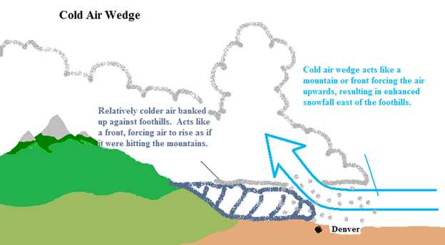
Cold Air Wedge:
This scenario occurs when colder air accumulates against the Front Range foothills, acting as a front that forces incoming air to rise before being redirected by the terrain to the west. This cold air wedge extends from the foothills eastward into the upslope flow, redistributing heavier snowfall onto the plains rather than concentrating it along the base of the foothills [Fig. 3 & 4].
While the Cold Air Wedge scenario can happen, the southwest and northwest flow scenarios are the most common situations when banded snow develops in Colorado. However, there are also other various ways in which snowfall can become banded or intensified, resulting in significant differences in snowfall amounts over short distances. Because of this, it remains one of the most difficult features to forecast for.
For additional information, refer to the resources provided by the National Weather Service: https://www.weather.gov/fsd/news_bandedsnowfall_20151121 .